Drought conditions worse than anything in living memory are making wildfire containment in the Wood Buffalo region more difficult.
Overnight Sunday, two to six millimetres of rain fell over the fire area, which was 474,450 hectares as of Sept. 2 and expected to keep growing.
Officials stress that the region is undergoing the driest season in living memory. In an 11 a.m. update Sept. 4, the notice pointed out the region’s “drought code” — which describes how little moisture there is in the soil, is currently around 1,100. Anything higher than 340 is considered extreme drought.
“What this means for the situation is the fire is burning deep in the ground through the duff layer – which is the layer of the forest just above the soil, full of decomposing leaves and other forest fuel,” said Wood Buffalo wildfire information officer Alyssa Etsell. “In discussion with long-term residents, Elders and fire specialists, no one has seen drought levels this high before.”
Currently there are 389 personnel, including 73 pieces of heavy equipment, 19 helicopters and 183 firefighters and structure protection personnel battling the behemoth, though the numbers are fluctuating as personnel shift out and are replaced with fresh team members.
As little as it was, the rain calmed the growth of the fire enough for workers to make progress in their defences. A 15-metre “wet line,” — heavily watered down vegetation — has been established around parts of Thebacha, and a low-level heat sensing scan conducted overnight identified hot spots for firefighters to attack during the day.
Plants that normally hold enough moisture to withstand strong heat for longer are now dry enough to ignite quickly, forcing a change of tactics in wildfire management. Often, these trees and wetter plants were integrated into fire barriers because of their resilience, but that strategy isn’t working this year.
Regardless, the plan remains to put enough fire breaks and containment lines through the area to stop the fire from spreading, then attack the hot spots individually. Work on a new containment line also began, with hoses connected directly into the Slave River.
“The idea of the containment lines is to create a boundary where there’s no fuel for the fire to continue burning,” said Etsell. “The containment lines can be built using dozers, firefighters with hand tools or using existing features such as roads, rivers, or open spaces. Once the fire arrives at the line, it has nothing left to burn and helps stop the wildfire from burning any further.
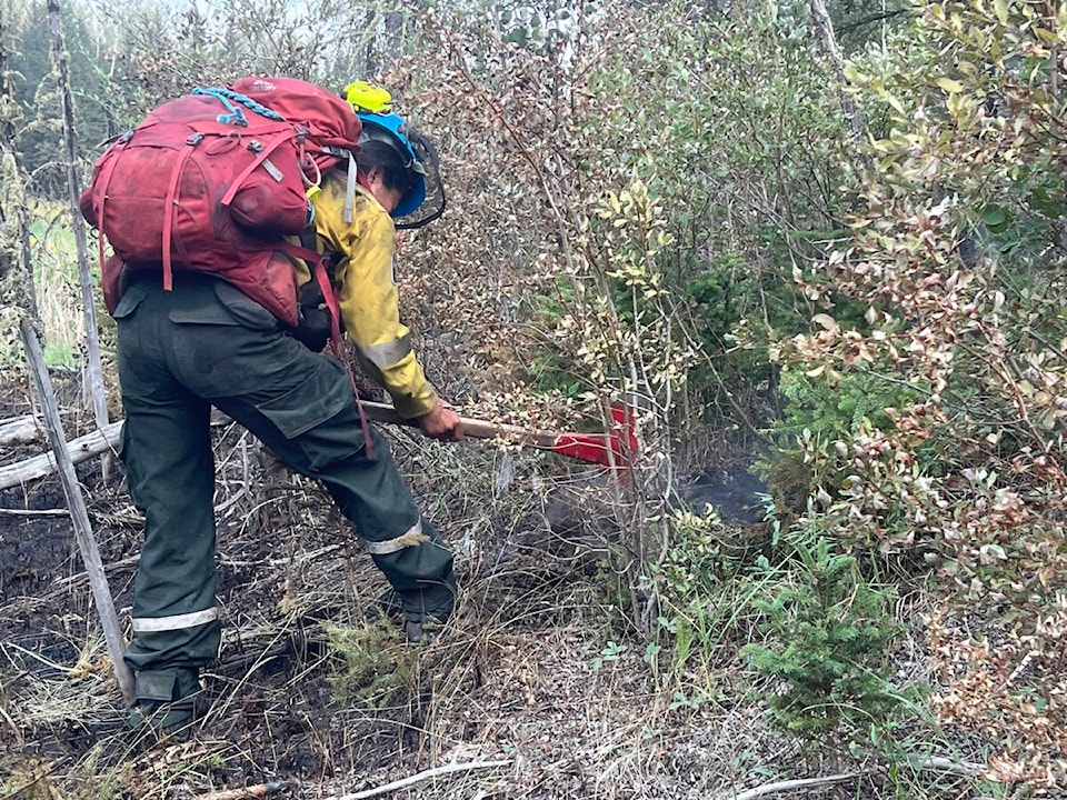
“Once the containment lines are established, firefighters can start extinguishing the fire off the perimeter. They generally start from the line or the fire perimeter, working their way in towards the fire. Once the fire is suppressed, hot-spotting begins. This is a very hard and long process where firefighters search for hot spots that’s either provided by a heat scan, they can also use their senses (sight and smell) to find smoke or fire burning deep in the soil. Once found, they will dig out the hot spot, extinguishing by using hand tools, water pumps and hose or at times, helicopters will assist the firefighters with water buckets.”
Attacking hot spots
Closer to Fort Smith, work is underway snuffing out hot spots on either side of Highway 5. A containment line south of Fort Fitzgerald is also nearly complete, according to unified command. Helicopters continue to provide air support when conditions allow for it.
Etsell emphasized that it’s imperative for residents not to attempt to head home prematurely.
“We know you’ve been away from home for awhile now, and we’re doing everything we can to get you back as soon as it is safe to do so,” she stated. “Please do not return to or visit evacuated communities. It is still unsafe for members of the public to be here. Large equipment, fire operations and structure protection systems require extra room and need to focus on fire suppression. There are limited supplies in the community – what remains is needed to ensure first responders are properly equipped to stay here and manage the incident.”
Fort Smith and Fort Fitzgerald, Alta., remain under evacuation order and state of local emergency. Highway 5 is closed between Hay River and Fort Smith. Pine Lake Road from Bordertown to Peace Point is also closed.