
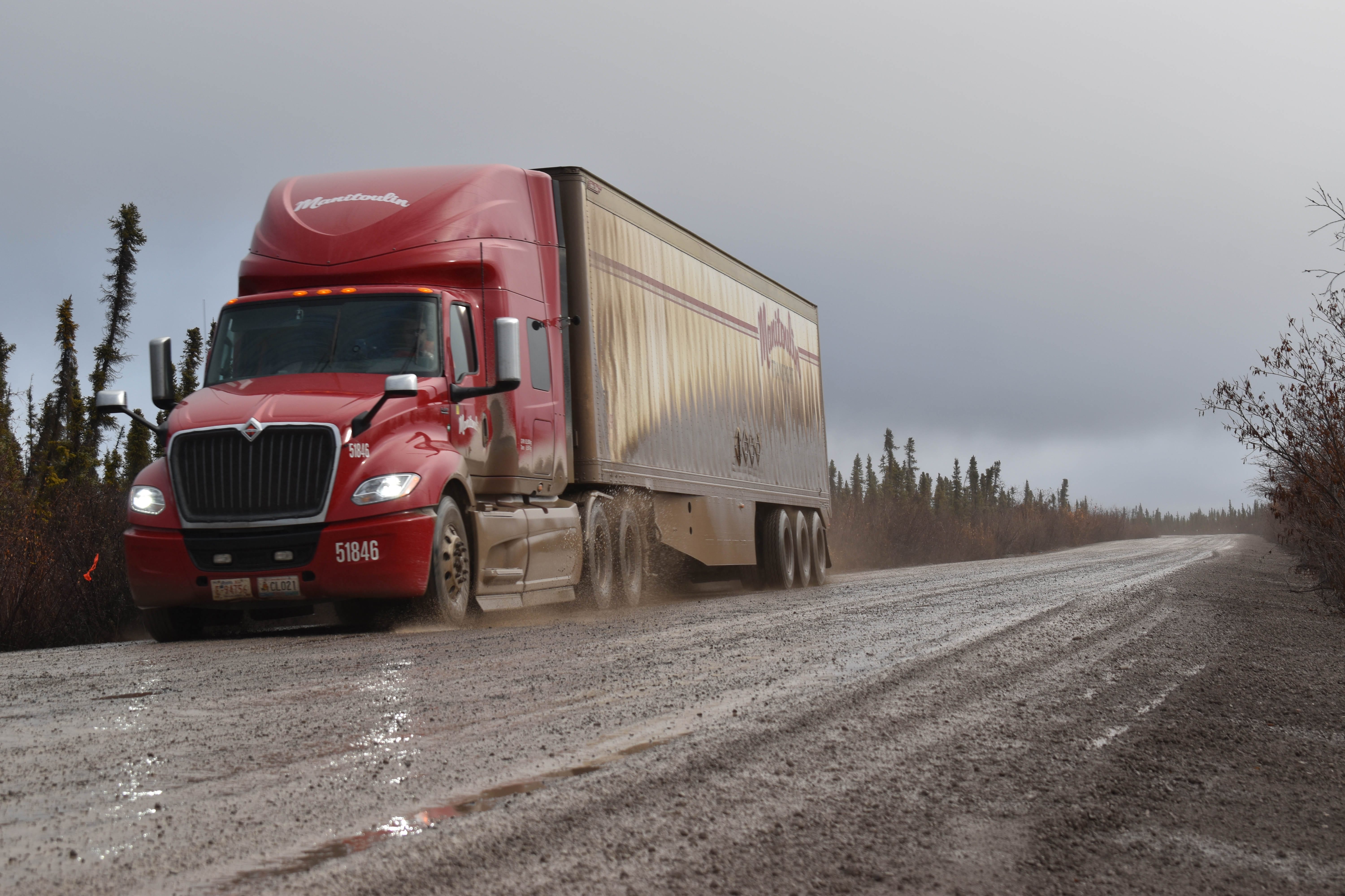
Nick Pearce / NNSL Photo
On any given a week up to 15 Manitoulin trucks rattle up the Dempster Highway to Inuvik, hauling the groceries and goods that make up thousands of residents' livelihoods.
“The state of the Dempster definitely affects … delays and things like that,” Inuvik Manitoulin office manager Elfie Gagne told Inuvik Drum. “(The) constant rain makes the road very slow and very treacherous.”
Downpours cause puddles, which muddy the drive and create rough conditions that demand maintenance. However, beyond weather, more permafrost melting may present a deeper challenge to the region's infrastructure and efforts to combat climate change.
“We have infrastructure that we rely on and need to have maintained. it would be very difficult for Inuvik to have food at the prices it has, if it was always flown in. We’ve got to have trucks driving up that road,” Carleton University professor and Western Arctic permafrost researcher Chris Burn said.
Groceries, heating and vehicle gas travel up the Dempster and keep Inuvik running.
However, along that route, gaping permafrost slumps expand, stretching to 40 hectares in an area of muddy base with icy headwalls up to 25 metres high, according to a GNWT report. These slumps open in areas of ice-rich permafrost, along hillsides and shorelines, and the GNWT reports that the Gwich’in and Inuvialuit also find they’re increasing, which could affect harvesting in the area.
Some of what the territory calls “mega-slumps” appear on the Peel Plateau, near the Dempster Highway and Fort McPherson. A 2018 University of Alberta study published in Geophysical Research Letters found the permafrost thaw in this area was increasing, and releasing chemicals that break down minerals and contribute to carbon dioxide entering the air.
How slumps happen
Burn explained that permafrost is ground that’s below zero degrees all year-round. In the summer, the air temperature goes above zero, “because people in Inuvik play baseball,” he said.
When the top section of the the ground falls out, this is called the active layer. When the summer runs longer or is warmer than in the past -- or when the winter is unseasonably warm -- that layer falls deeper.
“The summer case is easy to understand,” Burn said. “It’s getting hotter in the summer, so the ground should thaw to greater depths. If it’s a longer thawing season, a longer summer, you also think, it will fall to greater depths.”
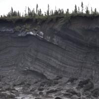
GNWT Photo
However, as a result of warming winters and falsl in the Western Arctic, the ground doesn’t become as cold. “So in the summer, you don’t have to warm the ground up nearly so much before it starts to melt, before the permafrost begins to thaw,” he said.
Burn explained that the mean temperature in the Western Arctic has increased by 3 C. In the 1960s, it was -9.7 C, and now it’s negative -6.8 C. Most of that warming is in the winter, Burn said. “That warming of the winter means the ground is nowhere near as cold as it used to be.”
As a result the soil loses its strength from retreating ice that acted as a cement. As the ice becomes water, it’s less of a cement. This affects the weight the permafrost can support – for things like buildings and infrastructure.
“If the ground loses its ability, if it loses its cement, then it loses its ability to support the building,” Burn said.
Slumps like landslides
It’s similar for roads such as the region’s main artery, the Dempster Highway. As a road goes up with an accompanying embankment, it puts pressure on the ground. If the ground warms underneath or beside the embankment’s edge, where large snow drifts gather, then a slump can occur.
“The permafrost can no longer support it,” Burn said.
Drivers can peek at these large slumps from the Dempster along the Peel Plateau, and potentially confuse them for landslides. One in particular, close to kilometre 126 on the NWT side, is visible, where material flows down the slope because the ice has ceased to be a strong support.
However, there’s still lingering questions about the affects of permafrost melt -- especially on the surrounding terrain.
“The behaviour of the terrain, and how water comes from that terrain towards the road, is something we’re really struggling with at the moment,” Burn said.
“What’s going on off the road is kind of tricky because we don’t usually know what’s happening off the road until there’s a problem,” he said. “Most of the time if there’s no problem, nobody goes to look for it.”
The variable terrain around the road makes it difficult to know enough about the subject.
As researchers parse these difficult questions, and infrastructure warps and buckles under new stresses, roads like the Dempster Highway will see new challenges with a changing climate.
“The problem itself is in many different layers. There’s the global scale, there’s the national scale,” Burn said. “And then there’s the local scale and there’s what’s actually happening at a particular bend in the road.”